Joining local election results with demographic data
A member of a civil rights organization was working with district-level election data they had obtained from a municipality. They wanted to join it with CVAP data, and planned to do so by downloading it at the VTD level from the Redistricting Data Hub website and aggregating it up to the districts. They contacted the Help Desk when they were unable to find the data at the VTD level for just the local jurisdiction of interest.
Typically, election results are reported at the precinct level, which are nested within legislative districts. When joining local election results with demographic data, it might seem logical to obtain demographic data at the VTD level and join that with the precinct-level election results, but we strongly advise against this practice. We prefer working with data at the lowest level of geography at which it is available – in the case of demographic data, at the census block level. By using smaller units of geography to aggregate up to district boundaries, there are usually fewer split geographies in the aggregation process.
The difference between precincts and VTDs
Counties tabulate election results at relatively small units of geography. These units are typically called precincts, but may also be called wards or election districts. Since they are created and maintained by counties, they do not necessarily align with census geographies, which are typically the building blocks for redistricting plans.
In an effort to help redistricting bodies, the Census Bureau attempts to collect these precinct boundaries from each state and release redistricting data aggregated to this level. The Census Bureau calls this level of aggregation Voting Tabulation Districts, or VTDs.
The precincts collected by the Census Bureau in the leadup to the 2020 decennial census may not be the ones that are in place for the 2020 elections in a state. States must collect these precinct boundaries from the county, and changes to these boundaries can occur at any time.
The Census Bureau includes a field in their VTD data, called “VTDI,” that indicates a discrepancy between the boundaries of the VTD and the precinct as maintained by the county in a state. It takes on a value of A for “actual” or P for “pseudo.” As the Census Bureau explains: “An ‘actual’ VTD is one that exactly matches the precincts or other election areas in your state. A ‘pseudo’ VTD is one that does not exactly represent the voting district spatially.”
Using data from the Census Bureau at the VTD level will more often than not reflect precinct boundaries that are out of date, and should always be used with caution. Even for precincts that the Census Bureau indicates are actual, there is still a chance that a county has changed the boundaries since they were submitted to the Census Bureau.
National VTD and Pseudo VTDs
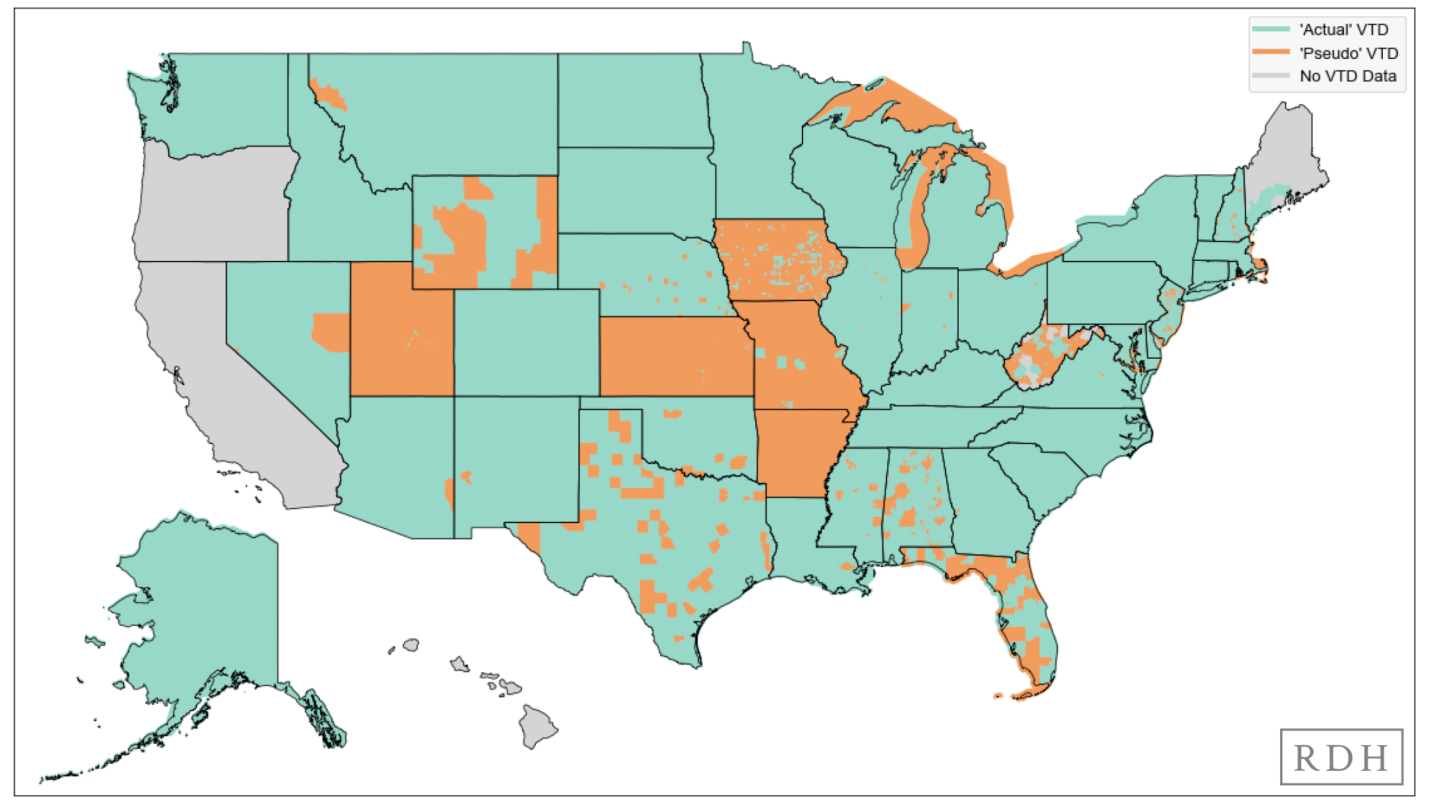
Actual VTDs are represented in green, Pseudo VTDs are represented in orange and No Data is gray.
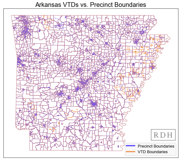
VTDs are represented in orange and Precinct Boundaries are purple. Note: AR has pseudo VTDs, which sometimes, but not always align with the precinct boundaries determined by our data partners.
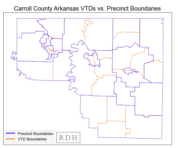
VTDs are represented in orange and Precinct Boundaries are purple.
Aggregating block level data to local districts
After discussing the reason why block-level demographic data is preferred, the Help Desk suggested downloading CVAP data at the block level, filtering it to retain only blocks in the census place (or city) of interest, then aggregating that to the city council districts.
Census blocks are typically used as the foundation for drawing legislative and congressional plans. This means that blocks are perfectly nested within districts, and block-level data can easily be aggregated up to these districts. Municipal boundaries, in contrast, may not perfectly align with census blocks.
In cases where parts of a census block overlap two or more city council districts, a decision must be made about how to allocate the data for aggregation. There are a few different approaches, but one common one – and the one we take here – is to assign the entirety of the block to whichever district contains more of its area.
The district level demographic data could then be joined with the district level election results. Having extensive experience in this kind of work, and to help the organization spend more time focusing on their goals and less time processing data, the Help Desk also volunteered to assist in creating this dataset.
Datasets necessary to analyze local elections
These datasets were necessary in order to aggregate and join census and voter file data with election results at the precinct level:
CVAP Data
2020 CVAP data at the 2020 census block level in shapefile format. It should be noted that CVAP data is only available at the block group level from the Census Bureau; our Data Team created a unique methodology to disaggregate the data by race and ethnicity down to the block level.
This dataset is available through the Redistricting Data Hub by creating a free account and filtering by type of data: demographic.
PL 94-171 Data
The PL 94-171 data at the 2020 census block level in shapefile format. This dataset contains census place codes not found in the CVAP data, that were used to filter census blocks to just those in the census place (or city) before aggregation.
This dataset is available through the Redistricting Data Hub by creating a free account and filtering by type of data: PL 94-171.Local Legislative District Boundaries
Shapefiles of city council district boundaries for the 2021 elections in Alabama.
The Redistricting Data Hub does not currently host local district boundaries, but we have created a guide for collecting local redistricting data. Contact the Help Desk for any questions or requests for assistance in collecting this data.
Local Election Results
These data were provided by the civil rights organization at the district level for 2021 city council elections in csv format.
The Redistricting Data Hub does not currently host local district boundaries, but we have created a guide for collecting local redistricting data. Contact the Help Desk for any questions or requests for assistance in collecting this data.
Creating a precinct level dataset to identify gerrymandering in your state
Understanding the many nuances around geography in redistricting, including the differences between VTDs and precincts, is critical for analyzing the legality of redistricting plans.
Merging demographic data (provided at geographic levels maintained by the Census Bureau) with election results (provided at a geographic level maintained by counties/precincts) is necessary to conduct racially polarized voting (RPV) analyses and identify racial gerrymandering at the local, state legislative, and congressional levels.